
Map Component
What are maps?
Maps enable you to see records in your database that contain Address Fields on a Google Map.

Adding Maps
To add a Map component, choose the Map component and then choose the data table to be used for this Resource.
Only tables which contain an address field will be available as an option for Maps.
Once you've chosen the table, you can choose Quick Add which will add the Resource component with some default settings. Alternatively, you can choose Customize to configure all the settings manually.
Choosing QuickAdd is simply a shortcut, you can always go right back into the component to make any changes necessary.
Inside the Resource component you'll see have some standard options available in other components, as well as unique settings only available in the Resource component.
Data Source
Map Options
Inside the Map Options is where you can set most of the map settings relating to this component.
Under General Options you'll have 3 basic options.

Title
This will be the title displayed on top of your map.
Description
This is a description for your own reference.
Address Field
This is the address field from your data table to be used for placing markers on the map. For example if each record has 2 addresses such as Home and Work addresses, you can only use one of those as the source for address fields.
Under Map Settings you'll have another 3 settings:

Map Size
This is the size of map height. By default, the map will always be the full width of its parent container. Only the height can be adjusted.
Zoom Level
The zoom level is the default zoom when the map first loads. This can be anything from 1 (Zoomed Out) to 20.

In general you can think of the zoom levels as:
- 1: World
- 5: Landmass/continent
- 10: City
- 15: Streets
- 20: Buildings
Map Type
The map type will determine if it should show Roadmap, Satellite, Hybrid or Terrain.

Under Interactive Options you can enable any interactive options available for this component.

Show List Panel
By enabling this option you'll be able to choose which values to show on the side panel next to the map.

Once this is enabled, you can customize what shows in each record by going to the List View inside the map component. When you have a List View enabled, clicking on one of the records will move the map to the chosen record and open the details in the Popup.
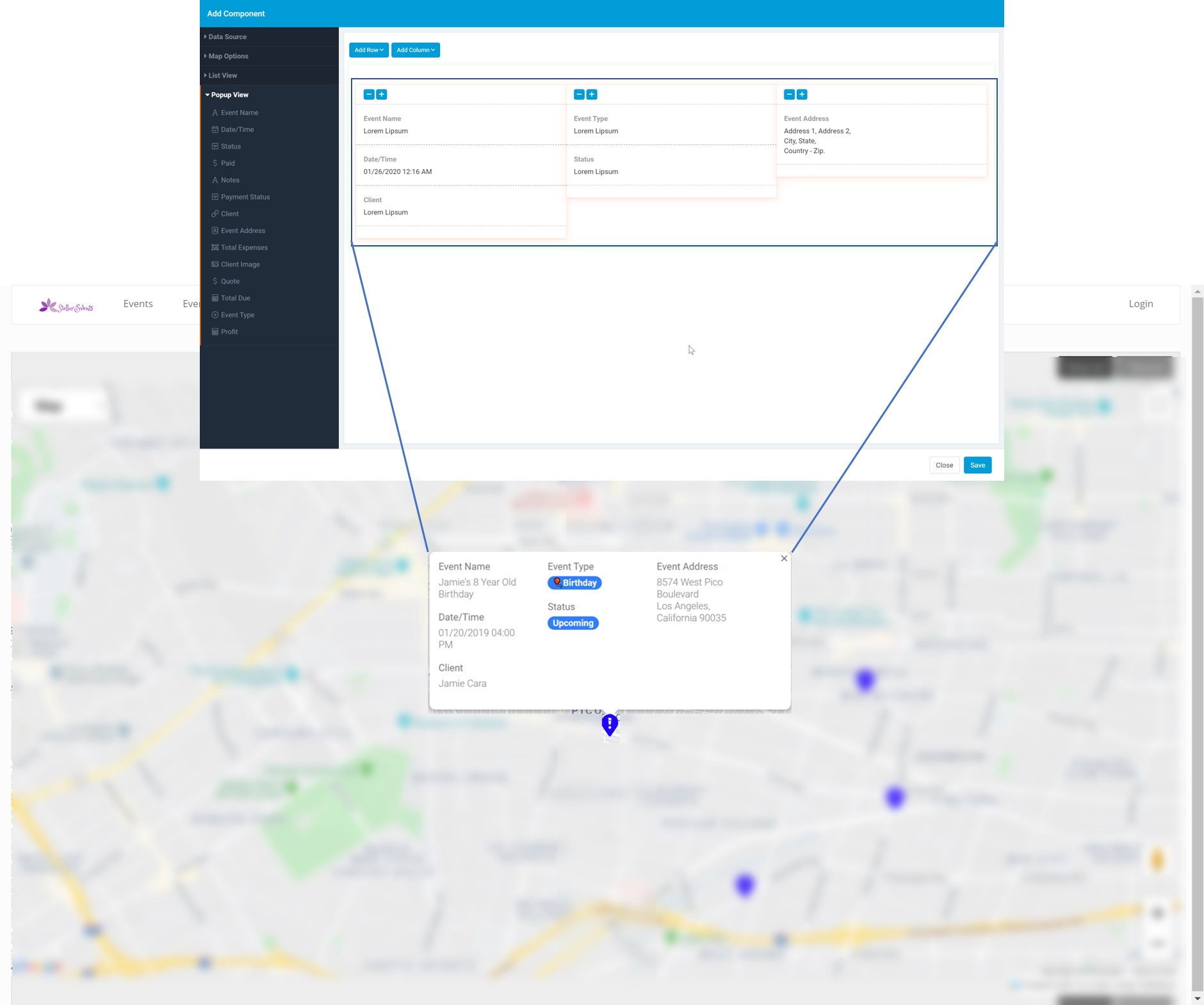
Enable Popup
Popup enables you to view more details when a Map Marker is selected. you can customize what shows in each popup by modifying the fields inside the Popup view.

Enable Scroll to Zoom
With this setting you can disable the scroll wheel on the mouse from zooming the map in and out.
Under General Options you can set the following options:
- Default Pin
- No Data Text
- Record Limit

Default Pin
The default pin is the icon that will be displayed on the map. You can customize the pin based on predefined conditions and when no conditions are met this pin will be used. Learn more about Pin Color Rules here.
No Data Text
This is what will show when there are no records to show.
Record Limit
Set a limit or allow all records to show up on a map.
Pin Color Rules
Here you can set color rules to determine which icon as well as its color to be used for each record.

List View
The list view is the section on the side of the page that will allow any details about each record you chose to add.

Popup View
Inside the popup view you can choose which fields will show up when a marker on the map is clicked. This only is an option when the Enable Popup option is enabled.
Maps and custom domains
If you're using maps with a custom domain, please let us know so we can white list your domain to ensure it works correctly.